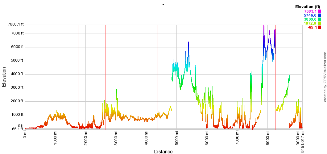
Amskeptic wrote:I liked your condensed elevation map of 2012 was it? It looked like a seismograph output. That was a Chloe drum brake lap.
Colin
Due to my frustrations creating maps in Google's new tool, this isn't chronological.
The high parts (dk blue, above 5,000') are in Montana Atlanticward and Pacificward of the Great Divide, and that higher cluster is around Los Alamos--traditionally the highest section of the itinerary.
Also shown is that the route is 9,151 miles long. Given that a few pieces are missing and that Colin consistently wanders off track, a total of 10,000 miles is a reasonable figure. So take that 10,000 miles, note that the route's elevation span is 7748.2
feet, a variance of 0.0146746%. That's equivalent to driving across a billiard table with an up/down variance of 0.5786 mm, corner pocket to corner pocket--in a really small bus, of course. The world is a very smooth place. (Not surprising, as the universe demands it be so.)
Moreover, all this driving means Naranja will cover her (his?) own length 35,571,590 or so times, on average 26,654 times on each of the itinerary's 134 days. Excluding complicating issues like turning, exact tire specs, and tire wear, each of her wheels will revolve 7,904,192 times, 58,967 times a day on average.